Pokémon Go Leads the AR Revolution

Pokémon Go Leads the AR RevolutionI awoke the other morning and thought about how this Pokémon things is kind of dumb. Then I thought about all of the things we do that also seem dumb, fishing, hunting, golf (all of which I’ve done in the past.) Heck, I even know of a person that manages to get laid off during turkey season. Now THAT’S dumb. Well, this Pokémon craze isn’t much different. And, it does get the kids out of their bedroom. I’m all for it, as I am for fishing, hunting, golf, all in moderation of course.

Click here to view original web page at Pokémon Go Leads the AR Revolution

Six months ago when I claimed that augmented reality was the future of GIS and geospatial services, it was met with a few sniggers. This week has seen the arrival of Pokémon Go, one of the most popular games to hit the mobile phone market, and yes, it is augmented reality and yes, it is geospatial. It could well be the turning point for many geospatial companies. What is Pokémon Go? In case you have been hidden in a cave for the last 25 years, Pokémon is a game […]

WTH: You’re Ignorant AND Can’t Tell Time?

WHAT THE HELL do you mean you’re not paying the rest of the survey fee? (I always get at least 50% retainer, for just this situation.)

So, you say my survey is wrong, why?

  “The tax map says I have 152 feet of frontage and you show only 141 feet. Your survey is WRONG.”

The 141 feet ± shown, sir, is a straight line distance from one pin to the other. Your property actually is a series of 3 curves and a straight line. You actually have the 151 feet of frontage along the right-of-way that’s shown in red.

  “So you’re saying my line is out in the street?

Well sir, in fact the pavement is actually built over your front line. Whoever paved it didn’t stay within the lines too well. (I said with a smile, trying to introduce some levity, which most times helps.)

  “YOU’RE CRAZY, SO I CAN JUST PUT UP A FENCE OUT INTO THE ROAD AND BLOCK THE STREET?”

Well I wouldn’t advise it sir, but it is your land. I recommend you call the City or County first and discuss it with them.

  “There’s no way that’s right. AND YOUR BILL IS WRONG TOO. Your guys were out here about an hour and they didn’t even know what they were doing.”

Sir, they were out there over 4 hours, you were with them the whole time. And, they are supposed to find as many corners as possible to check the pins that your neighbor’s surveyor set. They ended up shooting 3 or 4 pins on one side of your lot and all of your neighbors pins plus some more just to make sure yours was right. You asked for that right.? Plus, I discounted all that time off, down to our original contract amount. I ate that time.

  “So you came off my neighbors corners? I told you I thought they moved them. I’M NOT PAYING YOU TO SURVEY HIS PROPERTY.”

Well sir, another surveyor actually set the two pins between your land and his. They appear, from the FOUR hours work we did, to be in the right location, maybe a few inches too far on you, but not significant.

“WELL I’M NOT PAYING YOU. You’ll have to talk to my lawyer. He’s my father-in-law.”

The conversation was similar to that but much longer, and more heated than I can illustrate with words. But you get it, the guy didn’t like the answer he got – his out building was over the line over 3 feet, just as the other surveyor found. So, he starts attacking my professionalism and integrity, along with the crew’s competence and that they lied about the time (or that I did.)

I’ve never been to the Supreme Court, and I’m not sure this case will make it, but I’d like to go as far as it takes with this guy, just to wave my $300 in his face after he pays it. In reality, it will cost me $3000 (attorney, my time, and lost opportunity) and a sleepless night or two. Not to mention the frustration each time I think about it.

So, do I take it all the way to the Supreme Court, or do I let this guy get away with $300 of my money?

7/26/2016: As an Update, I joined LegalShield (formerly Prepaid Legal) and spoke to an Alabama attorney. His opinion was that because I did work ON the property and left behind stakes and flagging that I met the requirements for filing a lien against the property in Alabama. He sent a letter to the guys attorney (father-in-law) on my behalf. We’ll see. I do recommend LegalShield for your business, and not just because I might get a couple of bucks if you join. Well worth $39/month.

J. Keith Maxwell is a Professional Land Surveyor and Engineer in Alabama and frequently has conversations with people just to get his heart pumping faster. It’s usually about money. (Aren’t they all?)

WTH: Why the Hell is it Illegal to Bid Survey Work?

Why the HELL l did I just tell that guy that I can’t give him a price on $25,000 to $30,000 worth of work? He said “are you kidding me?” “I know it sounds idiotic sir but that’s the law here in Alabama. Our Board of Licensure says it is illegal for an Engineer and/or Land Surveyor in the State of Alabama to bid work. We would be putting our license at jeopardy. “ WTH?

In Alabama the Board of Licensure (BOL) regulates the practice of land surveying and engineering. All states have a similar entity for that state. I’m not sure about the Qualification Based Selection (QBS) regulations in each one though, but I suspect at least some are similar.

The 1992 Brooks Act

I first heard of QBS in the early 90’s – 1992 to be exact. It was introduced as a procurement process by the US Congress as a part of the Brooks Act, Public Law 92-582, according to Wikipedia. This was to be used by the federal government in the selection of Architects and Engineers. Land Surveyors were identified under the Engineering field at the time. After that, many States adopted their own version of the Brooks Act for themselves.

Having recognized that the “lowest cost” is NOT the best way to obtain professional services, this was done as a means to cut out this aspect of the selection process. This is often compared to you selecting a doctor. You wouldn’t necessarily choose a doctor based on what he/she charges for their services, would you?

Aren’t ALL Land Surveyors the Same?

A part of this, to me, is that the public ASSUMES that ALL land surveyors (or engineers, or architects, or lawyers) are generally of the same competency level, or quality level. This is related to the Time-Quality-Cost Triangle that I mentioned in a previous article. The problem is that ALL professionals are NOT the same, some are better, or more qualified than others for certain jobs. Now, we can’t CLAIM to be better than someone else, but it is obvious that there are differing competency levels among all the members of a profession. One of my favorite jokes is “What do you call a guy who graduates last in Medical School?” “A doctor.” Same goes for land surveyors, engineers, architects, and lawyers.

The Alabama Law Reference

Here is the direct law reference for professionals in Alabama: (emphasis added)

330-x-14-.05(f) The engineer or land surveyor,shall not participate in or implement procurement practices (bid submittals) which do not first determine the qualifications of the engineer or land surveyor prior to entering into fee negotiations for services being sought. An engineer or land surveyor having submitted a statement of qualification and performance data, and having first been judged as the qualified individual or firm to provide the services required for the proposed project, may proceed to negotiate a contract with a client and establish compensation or fees for the required services.

AND

330-x-14-.06 (a) The engineer or land surveyor shall not:

14. Participate in procurement procedures for engineering or land surveying services either by providing the bids or in requesting bids from other professional engineers or land surveyors where bidding is the primary consideration.

No Limits Before Law Applies to Professionals

Now, the most significant difference in the Federal and State Brooks Act and these references from the Law governing land surveyors and engineers is that there is NO LIMIT on when this law applies to Professionals under the Board of Licensure’s Law. The federal limit is $150,000 before the law applies. For the State of Alabama, the limit is $15,000 before the law applies. So, the Board of Licensure in Alabama has put the limit at $1 effectively by not giving a bottom limit.

This means that for ANY call that comes into our office WE, the professionals must explain the Brooks Act and QBS as it applies. Now, understand, it is NOT illegal for our potential clients to ask for Bids, just us to provide a bid. Again, unlike the Federal and State statutes, the one procuring the services is NOT responsible.

Summary

If you think that this is an undue burden on us as professionals, many agree with you. If you also think that having no bottom limit is idiotic, many agree with that also.

BUT, this is the law for Professionals in Alabama. Therefore, we must adhere to it or face consequences from our BOL who told us that they will “aggressively seek out and discipline” practitioners who may violate the “letter or spirit” of the BOL rules.

Our professional society, the Alabama Society of Professional Land Surveyors (ASPLS) has responded that they “see serious flaws with the concept at the workaday level and it is time for adjustments to be made.” But that has yet to be done. Hopefully the BOL will take this up at their next meeting.

Ref: http://alabamaadministrativecode.state.al.us/docs/eng/index.html

J. Keith Maxwell is a Land Surveyor and Civil Engineer in Alabama. He has to teach multiple people a day about QBS. At this rate everyone in America will know about it by 2096. He will be 135.

40 Years of Change in Land Surveying

This picture is of my Dad, Johnny Earl Maxwell (middle), my brother Joel (right), and an Uncle who’s land they were surveying. Joel is the only one of us who didn’t survey professionally. My brother Allen and I both followed in Dad’s footsteps to become land surveyors. But we were all introduced to this life early. As soon as we could chop a limb with a bush axe we were on the survey party. We learned to look back and stay on line, to tape distances, and to listen to orders barked out by Dad. “Your other left” being his favorite. “Right a hair,” a couple hundredths or “right a fuzz,” less than a hair, were measurements we also learned. We learned hand signals, because if there were radios, Dad was too cheap to buy them. Of course we would have run the batteries down playing with them anyway. But, beside the personal memories, I wanted to talk about the changes that have taken place in Land Surveying in the last 40 years or so.

Land Surveying Equipment

One of the first things I notice from this mid to late 70’s picture is that we, like most other surveyors, used a Surveyor’s Transit. I went with Dad to buy this used one, for about $700 at the time. Considering that in 1976 he bought a brand new pickup for $3,000, this was a lot of money. This instrument required you to read a vernier to obtain both the horizontal and vertical angles, to the nearest 20 seconds if I recall.

The distances were measured with a 100-foot steel tape. After lots of practice, and measuring the distance twice, we could probably get to within a tenth of a foot accuracy.

All the field notes were taken in a field book and then we hand calculated the traverse closure with latitude and departures. The drawings were done by hand with a protractor and scale.

Today we use a Total Station, which is a combination theodolite, electronic distance meter, and a data collector. Everything is digital and stored for you in the data collector, usually to the nearest second or two and the hundredth of a foot. This data produces coordinates which are then transferred to the computer for final drafting.

GPS on Railroad Track

All of this is much more precise than the older methods, and I haven’t even mentioned GPS yet. GPS has taken coordinates and precision to a whole other level. But thick tree canopy is still kryptonite to GPS.

Another recent invention is the Laser Scanner, which I re-posted a video about on Facebook recently. I may write an article about this instrument at a later time, but it’s a game changer for many applications, primarily as-built surveys.

Land Surveying Software

As I mentioned above, we wrote down all of our measurements in a field book, and then used a simple trig calculator to calculate latitudes (change in easting) and departures (change in northing) between two points. From this you would add up all of these changes for each line and hopefully get back to Zero. The error you got was the linear closure error. We summed the interior angles to compare to “(n-2) x 180 degrees”. And then the drawing was done by hand. Area was calculated by the DMD, double meridian distance method, a very long hand calculation process.

Today we have the data collectors attached or built-in to the Total Station and then can transfer that data directly to the computer, directly into a Computer Aided Drafting (CAD) program. Closure is checked in the program, then we either make some adjustments, or go on to connect the dots and then automatically label the bearings and distances of the boundary lines. Acreage is calculated with the push of a button. The legal description can also be written almost automatically, except for a few personal preference edits.

Surveying Precision is Better

The definition of precision is “the repeat-ability of a certain measurement.” With more and more precise measuring tools, the closer you can get to the actual measurement of an angle or a line. This then gives more precise area measurements. All measurements have errors. But, generally, the more precise your measurements, the more probable your accuracy, or “closeness to the actual measurement” you should be.

This is a good thing considering that the value of land is extremely more than 40 years ago. Even small mistakes now are a big deal. When distances were measured with a Gunters’ chain, measurements were within one link, about 8 inches, or 0.66 feet. Today we should be 30 times better.

Land Surveyors are Different

Of course, the old man is older still today, but that’s not what I mean. Land Surveyors today are expected to have MUCH more knowledge than in years past. In most states a 4-year land surveying degree is required to become a land surveyor. In addition, the experience required is increased.

A surveyor is also expected to have a clear understanding of the laws that govern land surveying today. There are many cases from the courts that have changed the way land disputes are decided, and surveyors must stay up to speed on these. But there are also older legal principles which haven’t changed over the years. And, I personally think that we as surveyors haven’t done enough study of this facet of land surveying. There are a few issues today that divide land surveyors as to the proper way to handle them. One, for example, is the division of a section into aliquot parts. Should you re-measure the entire section out with our more precise methods and re-divide the section into quarter-quarters, or should we hold to corners long accepted as the quarter-quarter corners? I believe the latter, but there are those who will debate me on that.

Summary

Is land surveying better today, or are land surveyors better? Well, we have better equipment and software, and we have access to more knowledge than ever before. So, it’s possible for us to do a better job and faster, but it still takes a conscientious and studious practitioner to be a better land surveyor.

J. Keith Maxwell is a Land Surveyor and Civil Engineer in Alabama. He started surveying in the Cheaha mountain area of the state and has since gotten out of the woods completely, mainly sending others out. He feels it’s much nicer looking back fondly than actually being out there chopping bushes.

WTH: Why The Hell Am I Working at 11pm?

As the kids say on text, WTH? Whiskey Tango Hotel? Why the H E double hockey sticks was I still working at 11:00 pm on Friday night? And why is my phone ringing again at 6:51 am on Saturday morning ABOUT THE SAME JOB?

Maybe this has happened to you – someone calls frantic, normally a realtor. They are at the closing or on the day of the closing and find out they need a survey.

“Nobody Told Us We Needed a Survey!”

Wait, you’re a REALTOR, you went to the classes, all 60 hours of them. You passed the test. You took some more classes, another 30 hours. Now you have a license to collect about 1.5% commission on anything you LIST and/or SELL. You work for a BROKER, who gets another 1.5% commission on that same transaction. And you didn’t know that you need a survey? Or, you don’t want to advise your client that is buying the land that she NEEDS to know where the property lines. After all, she is spending $100,300 for this home and 9 acres of land. (Wow, that seems cheap, but that is beside my point.) Even at that low price, that is a significant investment. What if they want to put up a fence? What if their neighbor is encroaching? There’s endless what if’s. Just read the title insurance policy to see all of them. And, speaking of the title insurance policy, did you read the part that says if you don’t have a survey they won’t cover anything that comes up that a survey WOULD have found?

Did the buyer get a look of the tax map (above)? Did you look at the tax map? Did you see that there was 3800 linear feet of property boundary lines, with 11 sides? Did you see that it is ALL wooded? (And the Parcel number is unlucky #13, but you can’t help that.)

OK, maybe you don’t know why you should have a survey. That’s my fault, or at least my profession’s fault for not educating you AND the general public. Let me educate you – YOU ALWAYS NEED A SURVEY. You need a survey as much or more than you need a Realtor. Just sayin’

“Lot Surveys Are Normally $400”

Yes, I know “lot surveys are normally $400,” or around that. This ISN’T a lot survey. A“lot survey” is normally a small lot, less than an acre, in a platted subdivision, which has been surveyed and pins set when the subdivision was done. This is a larger tract of land, over 9 acres, and we don’t know if it has EVER been surveyed. A boundary survey is required. And, DID YOU LOOK AT THE TAX MAP?

“Why Is It SO Much?”

So, “Why is it so much?” Well, did you look at the tax map or the deed? “Realtors don’t usually get the deed.” OK, maybe you should, especially if you’re the listing agent. That’s worth at least as much as a picture of the property. So is a picture of the Tax Map. (Note to self, I need to tell you about the difference between a tax map and a survey map.) And, an old survey would also be great. If I were a listing agent, I’d round all of these things up, as well as maybe the flood map and have a picture of them on the listing. Us surveyors would LOVE you for it.

The Size and Shape of the Parcel Affects the Price Most

OK, the reason that it’s so much is that this is a 9 acre parcel with 11 sides all in the woods. AND, you’re wanting me to do the work on Saturday and Sunday. And then at 11:00 pm you tell me your client wants to get another price. (Remind me to tell you about how we also can’t BID for survey work.)

Eight Years & Two Exams Passed To Practice Land Surveying

And, I’m a licensed surveyor. In Alabama now, that requires me to have a college degree in Land Surveying. Then I can take the first EIGHT hour Land Surveyor Intern test. Then I have to have FOUR years of experience working for another surveyor before I can take the EIGHT hour Professional Land Surveyor license exam.  When I took the test, I only had to have a four-year degree and 2 years of experience before I could take the 16 hours of exams. And, they only have about a 50% pass/fail rate.

Significant Equipment Expense

Now, let’s talk about the equipment we have to have in order to do the survey. In addition to the two or three employees in the field and the drafter in the office, the equipment investment is significant. A surveying instrument setup to do a basic boundary survey is in the $20,000 to $35,000. Computer and Software adds another $5000 minimum. And, if you have GPS, and most surveyors need it now, that will set you back another $15,000 to $30,000.

Continuing Education

Then, there’s continuing education, 15 hours each year. Most of us get way more than that. We have to stay on top of new technologies, we have to read the law and court cases, know federal, state, and local standards for doing our work, manage employees, handle mandated business issues, manage contracts and collections, and make “professional judgements” about where to set pins that can’t be found.

Time-Quality-Cost Triangle

Good - Fast - Cheap Triangle

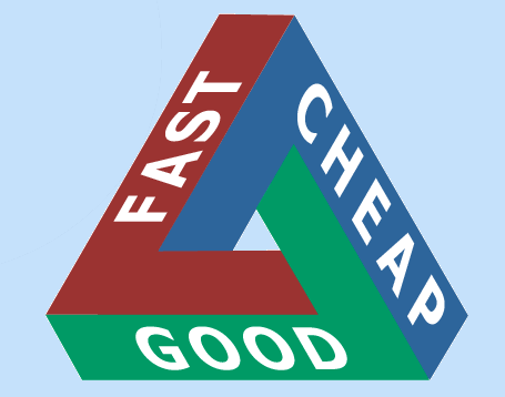
You may have seen the above triangle. This is a common pricing model for many types of service. You can pick ONLY two of these factors. In our profession, one of the factors MUST be GOOD by law. It is unethical for us to do a poor job on a survey.  So, you only choose between fast or cheap.

Good + Cheap = Slow

Good + Fast = Expensive

Summary

I’m NOT saying that my job is harder than yours. It’s different. I’m not really concerned with what commission you charge. You should get paid for the work and value you provide, and most folks can’t sell their house or buy a house without an agent. They could very well make a mistake worth more than the sales commission. I just want the same courtesy, to be paid for my knowledge, work, and value that is put into the survey of a parcel of land and to have you, as a real estate agent, understand the role that a professional land surveyor plays in the whole real estate ownership process.

J. Keith Maxwell is a Professional Land Surveyor and Civil Engineer in Alabama. He stays up late at night and wakes early to answer questions that frantic real estate salespeople ask, hoping to meet their and their clients needs and to gain a loyal customer for the future. He lives in a constant state of frustration.